
Wednesday, June 11, 2014
Big Engineering 67 Greening Western China
Some years ago I did a number of articles about bringing water to deserts. In particular was this one on Greening of Central Asia. Taking the 650 cubic km a year from Lake Baikal and, instead of letting it flow into the Arctic Ocean, redirecting it through a series of tunnels along the Mongolian & Chinese borders into and across the central Asian republics to the Caspian Sea.
That is a lot of water. More than 7 times the Nile's output.
Something I have only fairly recently realised is that western China's water basin is largely unconnected to China's coastal region. Which means water in that area would, if there was enough of it, would ultimately flow west too.
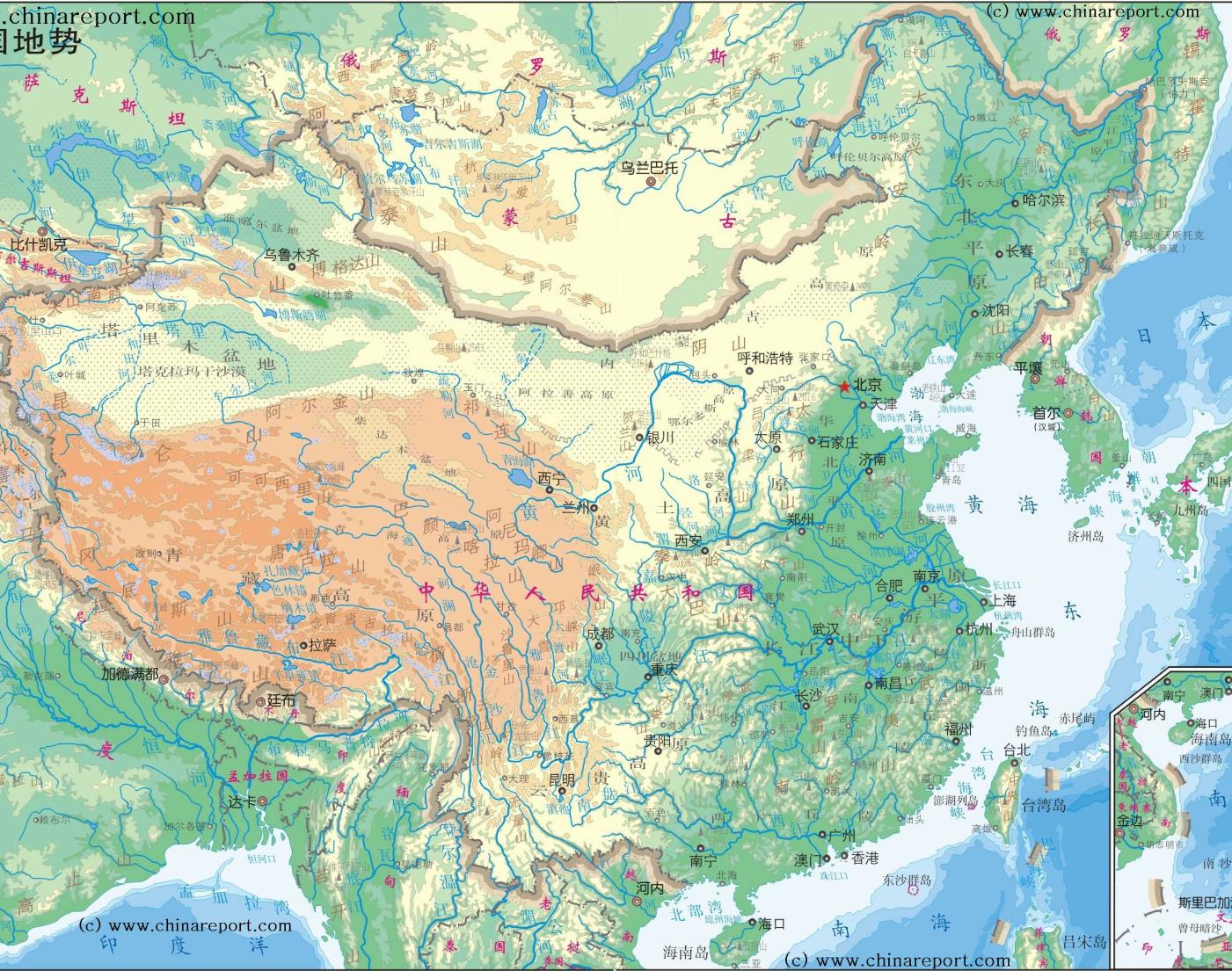
This map shows ground levels fairly well. Lake Baikal at the top has both yellow and green coloured land beside it so must be almost exactly on the line between the 2. So tunnels or canals could carry water across any of the yellow areas.
The distance from Baikal to the point on the Mongolian southern border where the highest ground is is 1,000 km. I'm not sure whether there is or isn't land above the Baikal level all the way or a few miles where an aqueduct would be required. From there the distance to the Tarim basin (the oblong at the west bordered by the Himalayas and a row of mountains on the western end) is about 700 km.
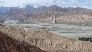
The Tarim basin is one of the driest areas in the world. Rain doesn't get in (or out) from the central Asia region because of those mountains. The river Tarim (the longest) and others are some of the few rivers in the world that never wander down to the sea. Instead they peter out in the Lop Nor salt marshes (sufficiently unattractive the Chinese once used them for their nuclear tests). This is what it looks like now:

However, as the map shows, much of this land is at the green level, below the level of Baikal. A couple of year's flow from there (ie 1300 cubic km) would make a big difference. The major green zone there looks like about 50,000 square km but I don't think any of it would end up more that a few tens of meters deep. 650 cubic km would fill that to an average of 10m in 9 months but probably at least twice that as dry ground soaks up water. Because of the mountains that stop moisture getting in, we could expect moisture to stay in the area and get a decent rainfall. After that the water can be drained into the green zone to its north and then, by tunnel through the mountains to the green zone above and then in turn back across the Chinese border to Russia and rejoining the line from Baikal to Kazakhstan which I previously wrote of.
The absolutely enormous amount of water available means that while it might take 4 years longer for the water to reach the Caspian there is plenty to go round. This would not have been the case if the water had drained eastward towards the sea, but it doesn't.
That means a total of about 1,800 km of tunnels. At Norwegian costs of £4m per km it would be about £8bn but I suspect the tunnels would have to be wider, or even duplicated and the total would be several times that. Still pretty minor for such a great increase in the fertility of the worlds most populous and now richest state. Less, possibly much less, than running a railway to Bradford.
Of course the real expense is buying the water from Russia. Russia and Mongolia would reasonably want quite well paid. China might feel they are now strong enough to grab it. On previous cases I have said that the way to deal with political issues on these Big Engineering articles is simply to ignore them and treat the question as purely what can be done in engineering terms. I'm going to do that again but lets be clear - it is a big issue.
UPDATE
I have this comment which is of importance:
Hi Neil - an impressive idea, though I find the numbers a bit daunting. 650 cubic kilometres per annum requires an AVERAGE flow of 20,610 cubic metres per second. Our river Tay is the largest in the UK by annual discharge and it's peak flow is about 1,965 cubic metres per second. A typical 8 metre internal diameter tunnel has a cross section area of about 50 square metres , so even if the water was flowing at a whopping 10 metres per second (36 km per hour)you would require 42 such tunnels.Remember also you wish to use gravity as much as possible and to cover the distances you are talking about the cross sectional area of the aquaduct has to increase greatly as the flow rate needs must be slow for such a distance from a limited drop in elevation. Without pumping of some sort you are not talking of a few tunnels, but a broad canal possibly 30 times the combined width and depth of the Tay at Perth
----------------------------------------------------
That is an issue.
We could double the diameter to quadruple cross section area but the wider it gets the weaker it is so we can go up to the size of the Norwegian ship tunnel but anything else is going to need expensive reinforcing. I think the flow would be considerably lower than 10 meters because the gradient over the entire distance is low.
Even assuming major economies of scale that sounds like app £80 bn rather than £8 bn. Still that is inexpensive for more than a million square km. It would also mean that it would take more than a year or 2 to put it in place.
It might well turn out, bearing in mind that the depth here is not to great, that it would be cheaper to cut down from the surface and create an artificial canal. The aqueduct might also be replaced by an above ground canal held there by dams. All a matter of the most cost effective way.
That is a lot of water. More than 7 times the Nile's output.
Something I have only fairly recently realised is that western China's water basin is largely unconnected to China's coastal region. Which means water in that area would, if there was enough of it, would ultimately flow west too.
This map shows ground levels fairly well. Lake Baikal at the top has both yellow and green coloured land beside it so must be almost exactly on the line between the 2. So tunnels or canals could carry water across any of the yellow areas.
The distance from Baikal to the point on the Mongolian southern border where the highest ground is is 1,000 km. I'm not sure whether there is or isn't land above the Baikal level all the way or a few miles where an aqueduct would be required. From there the distance to the Tarim basin (the oblong at the west bordered by the Himalayas and a row of mountains on the western end) is about 700 km.
The Tarim basin is one of the driest areas in the world. Rain doesn't get in (or out) from the central Asia region because of those mountains. The river Tarim (the longest) and others are some of the few rivers in the world that never wander down to the sea. Instead they peter out in the Lop Nor salt marshes (sufficiently unattractive the Chinese once used them for their nuclear tests). This is what it looks like now:
However, as the map shows, much of this land is at the green level, below the level of Baikal. A couple of year's flow from there (ie 1300 cubic km) would make a big difference. The major green zone there looks like about 50,000 square km but I don't think any of it would end up more that a few tens of meters deep. 650 cubic km would fill that to an average of 10m in 9 months but probably at least twice that as dry ground soaks up water. Because of the mountains that stop moisture getting in, we could expect moisture to stay in the area and get a decent rainfall. After that the water can be drained into the green zone to its north and then, by tunnel through the mountains to the green zone above and then in turn back across the Chinese border to Russia and rejoining the line from Baikal to Kazakhstan which I previously wrote of.
The absolutely enormous amount of water available means that while it might take 4 years longer for the water to reach the Caspian there is plenty to go round. This would not have been the case if the water had drained eastward towards the sea, but it doesn't.
That means a total of about 1,800 km of tunnels. At Norwegian costs of £4m per km it would be about £8bn but I suspect the tunnels would have to be wider, or even duplicated and the total would be several times that. Still pretty minor for such a great increase in the fertility of the worlds most populous and now richest state. Less, possibly much less, than running a railway to Bradford.
Of course the real expense is buying the water from Russia. Russia and Mongolia would reasonably want quite well paid. China might feel they are now strong enough to grab it. On previous cases I have said that the way to deal with political issues on these Big Engineering articles is simply to ignore them and treat the question as purely what can be done in engineering terms. I'm going to do that again but lets be clear - it is a big issue.
UPDATE
I have this comment which is of importance:
Hi Neil - an impressive idea, though I find the numbers a bit daunting. 650 cubic kilometres per annum requires an AVERAGE flow of 20,610 cubic metres per second. Our river Tay is the largest in the UK by annual discharge and it's peak flow is about 1,965 cubic metres per second. A typical 8 metre internal diameter tunnel has a cross section area of about 50 square metres , so even if the water was flowing at a whopping 10 metres per second (36 km per hour)you would require 42 such tunnels.Remember also you wish to use gravity as much as possible and to cover the distances you are talking about the cross sectional area of the aquaduct has to increase greatly as the flow rate needs must be slow for such a distance from a limited drop in elevation. Without pumping of some sort you are not talking of a few tunnels, but a broad canal possibly 30 times the combined width and depth of the Tay at Perth
----------------------------------------------------
That is an issue.
We could double the diameter to quadruple cross section area but the wider it gets the weaker it is so we can go up to the size of the Norwegian ship tunnel but anything else is going to need expensive reinforcing. I think the flow would be considerably lower than 10 meters because the gradient over the entire distance is low.
Even assuming major economies of scale that sounds like app £80 bn rather than £8 bn. Still that is inexpensive for more than a million square km. It would also mean that it would take more than a year or 2 to put it in place.
It might well turn out, bearing in mind that the depth here is not to great, that it would be cheaper to cut down from the surface and create an artificial canal. The aqueduct might also be replaced by an above ground canal held there by dams. All a matter of the most cost effective way.
Labels: Big Engineering, International politics, Science/technology
Comments:
<< Home
Hi Neil - an impressive idea, though I find the numbers a bit daunting. 650 cubic kilometres per annum requires an AVERAGE flow of 20,610 cubic metres per second. Our river Tay is the largest in the UK by annual discharge and it's peak flow is about 1,965 cubic metres per second. A typical 8 metre internal diameter tunnel has a cross section area of about 50 square metres , so even if the water was flowing at a whopping 10 metres per second (36 km per hour)you would require 42 such tunnels.Remember also you wish to use gravity as much as possible and to cover the distances you are talking about the cross sectional area of the aquaduct has to increase greatly as the flow rate needs must be slow for such a distance from a limited drop in elevation. Without pumping of some sort you are not talking of a few tunnels, but a broad canal possibly 30 times the combined width and depth of the Tay at Perth
# posted by  : June 12, 2014
: June 12, 2014
That is an issue.
We could double the diameter to quadruple cross section area but the wider it gets the weaker it is so we can go up to the size of the Norwegian ship tunnel but anything else is going to need expensive reinforcing. I think the flow would be considerably lower than 10 meters because the gradient over the entire distance is low.
Even assuming major economies of scale that sounds like app £80 bn rather than £8 bn. Still that is inexpensive for more than a million square km. It would also mean that it would take more than a year or 2 to put it in place.
It might well turn out, bearing in mind that the depth here is not to great, that it would be cheaper to cut down from the surface and create an artificial canal. The aqueduct might also be replaced by an above ground canal held there by dams. All a matter of the most cost effective way.

Hi Neil - I did a bit more looking on Wiki and discovered that at it's narrowest Suez canal is 205 x24 metres squared, so your aquaduct with a flow rate of 1 metre per second would be fully four times the size of the Suez canal. As you know shipping is the most energy efficient form of transport ( even against a i metre per second current? - still the vessels going the other way would have that advantage ) The point is would that boost to development in it's many forms justify the world's biggest and longest ship canal being placed in central asia. The surface elevation of Lake Baikal is about 455 metres above sea level. I don't know the elevation of the places you wish to irrigate but it would be rather important to find out
# posted by : June 13, 2014
: June 13, 2014
I would say yes, not just because greening approaching half the land area of the world's most important country is no small thing, but also because our capabilities (if not our ambitions) are enormously greater than during the Victorian age when Suez was cut. That canal was built with human labour and steam power - anything we do is now much easier.
I would say yes, not just because greening approaching half the land area of the world's most important country is no small thing, but also because our capabilities (if not our ambitions) are enormously greater than during the Victorian age when Suez was cut. That canal was built with human labour and steam power - anything we do is now much easier.
Post a Comment
<< Home
![]()